Still Portfolios
For three of the past four years, I have been in Mongolia, an unexpected and productive change of directions for me. As a result, I am over my head in new images, several book projects, and some short pieces of video. Please check my Mongolia notes, which contain a wide selection of work from that country. I also have work-in-progress and other observations in sketches and notes. Here is where I left off...
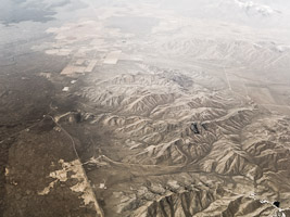
MSO > SLC: Spring
I am fascinated by the natural process of erosion--and never more so than when observed from several thousand feet in the air. From this vantage point you can see not only what is left by the process, but with some imagination for the time this might take, what has been washed away. Long ridges flank wide valleys, which from the geological evidence, were once all the same height.From this perspective you can also see the use that we humans have made of the land, from Missoula to Salt Lake City a progression from logging, to irrigated agriculture, the grazing of cattle who are limited by strands of steel pulled into straight lines, to various forms of extraction and energy transmission that end in the bulldozing of salty soil left behind as the level of the Great Salt Lake recedes.
Other Explanations
A recent op-ed article in the New York Times noted that in addition to Donald Rumsfeld's "known knowns, known unknowns, and unknown unknowns," there is also a class of information that is effectively the "unknown knowns," facts which have been widely known but which we choose to "unknow."This is work-in-progress that deals with the rightness or wrongness of displaying and interpreting visual fact. The images are from Pennsylvania, Utah, Montana, and Wyoming. They ask you to reject at least part of what looks right to understand the bigger and more complicated story of how this geology was formed and how it has come to rest in its present position. There are ways to deny this evidence, but not without committing serious leaps in the "unknowing" of scientific knowns about the age of the earth and the time required to see change of this magnitude. Several of these images are meant to be displayed in pairs, one image compared to another. I had two of these images framed for a show, and took it as a measure of success that when I picked up the 40" wide prints from the frame shop, the wires had been attached to the wrong sides of one of the images.
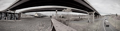
Intersections
Even though, or more likely because, these structures are not built for pedestrians, they provide an unexpected sanctuary for those traveling by foot. The chain-link fences and No Trespassing signs only make these places more attractive for those looking for a public place to go unnoticed. Tucked up under these bridges are the temporary dwellings of the homeless, who sometimes amass large nests of possessions only to abandon them when they move on. One morning I came across a fresh bouquet of roses and a bag of candy on top of a mound in the middle of Rochester’s Can of Worms, one of the busiest intersections in the city and oddly, a perfectly private spot for what I took to be an adolescent rendezvous. When I came back through in the afternoon the flowers and candy were gone. The fact that these spaces are not meant to be viewed closely makes them havens for both growth and decay. Initially cleared for construction, vegetation goes through its annual cycle unimpeded by the other roadside customs of pruning and mowing. Ponds fill with the growth of cattails just as naturally as concrete is stained by corroding structural elements. Along the road and at the base of embankments are the detritus of travel gone wrong—not just hub caps, headlights, and tires, but a fender from a tractor trailer, a car door, an alternator the size of a watermelon, or earth that is blackened by fire.
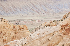
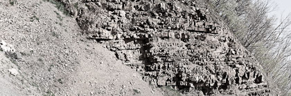
Sand, Rock, Water, Time
Except at road-cuts and at the tops of the relatively few high mountains, what you see traveling through the east is either biological, architectural, agricultural or industrial. Travel two days west of the Mississippi by car though, and the word geology takes on a different meaning. Instead of being just a branch of science, a topic of study that deals with rocks and the formation of the earth, it becomes the best word for what is moving past your windows as you sit behind the wheel of your car, or what your feet rest on as you make your way along the fragile edge of a wash.These are distilled geological details found while hiking and driving through Utah and South Dakota at different times in the summer of 2011. A larger collection of the same name is available as a book.
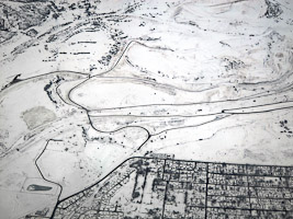
MSO > SLC
Just after 8:45am on January 5, 2011, Delta flight 4876 pulled away from the gate and headed for the de-icing area in Missoula, Montana. A few minutes later it taxied for the end of runway 11 and was cleared for takeoff. At 9:11 the pilot pressed the throttle to the dash and our Canadair CRJ 200 pushed its passengers to the backs of their seats. The nose lifted, and we became airborne.
I had bargained for a window seat, as I always do. At first there was little to see, being on the very western edge of Mountain time, a week and a half from the winter solstice, at 47° north latitude. But out of the gloom, as the last drops of de-icing fluid rolled across the window of seat 4D, a gray landscape appeared. At 9:13:09, looking southwest, we crossed the broken branches of Clark Fork as it meandered toward the Bitterroot. At 9:13:27 we passed a prominent oxbow in the Bitterroot that marks the southwest edge of town. By 9:17:31, we had climbed above pale peach-colored clouds to a blue sky.I know this not because I was looking at my watch and taking notes, but because I was taking pictures with a small digital camera. Along with the image data it captures, it records, to the second, the time on its clock. This data can be used to track the entire progress of the flight. By plotting the identifiable views and interpolating the unknowns, each of the images can be located on Google Maps, and compared to the same view on Google Earth.
The existence of Google’s archive of images begs the question, Why photograph what has already been photographed? For me the answer is this small collection of images, taken under conditions that would render most aerial photography useless. There were overcast skies and fog. The ground was covered with snow. The early light was low, causing deep areas of shadow. Bad if you are looking for information about the surface of the earth, but good if you are going for its structure and form.
Recent Artifacts
On a hot day at the beginning of September, I had an opportunity to visit an archeological site that has revealed some discoveries that have changed our understanding of human history and migration. Arrow and spear points, fire pits, and bone fragments have been found that date back 19,000 years before the present. That would not be so startling if the site I visited was in Africa, or Asia, or even Europe. This site is in southwestern Pennsylvania, west of Pittsburgh, as any person on foot for many thousands of years would have traveled, seven and a half miles upstream of the Ohio River on what we now call Cross Creek. Prior to this discovery, the earliest humans were thought to have arrived in North America six to eight thousand years ago.The Meadowcroft Rockshelter is a sandstone overhang situated high above the creek, where generations of tool making travelers took shelter on their travels in this area. Underneath the shelter of this overhang, a large flat area was the resting place for these travelers. And as is still the case today, when these travelers left, they did not always take everything they came with. As a kid, before it was developed, I had an opportunity to run around in this site, hearing stories that Indians had once lived there. It is possible that in the very first layer of excavation the archeologists might have found loose change, a marble, or a baseball card.
These are images of some artifacts of our time, pre-discovered by casting them in plaster and photographically grafting them to images of fossil-bearing Devonian rocks. I had originally created them with an interesting but complicated formula in mind, which went something like:
Lost keys/Devonian fossils = Creationist age of earth/Geologist age of earth
The visit to Meadowcroft helped to reframe these very recent discoveries, and has me thinking about what else might be discovered. Fifty pounds of mold-making clay are sitting on my workbench.
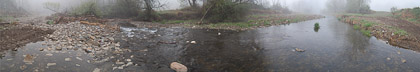
Canacadea
During the period between March, 2008 and May, 2009 I was living in Alfred, NY, working on my MFA at Alfred University. I stayed on property that bordered Canacadea Creek, and as part of my routine I began to photograph it as often as my schedule allowed. Within a few weeks I spotted beavers and began to anticipate the exciting changes that could happen. When the beavers moved on, I was left with what I thought was to be the steady progress of the seasons. Around that time the landowner removed a logjam and cut an access road beside the stream. Over the course of the winter, ice covered the stream, and in the spring, high water nibbled away at the stream bank as well as the newly cut road. Action was taken to preserve the road, but it was no use, for once the stream had decided to change course there was no stopping it.